Orange County,
New York
Hiking Trails:
Sweet Clover Trail: White blaze
Dark Hollow Trail: Black blaze
Jessup Trail: Yellow blaze
Total Time: 4:30 hour
Estimated Distance: 6.75 miles
Level of Difficulty: Difficult
Level of Recommendation: Highly Recommended
Points Of Interest: Large grassy meadow, Megaliths
Pros: Good climb, amazing views, interesting rock formations, and varying terrain
Cons: Beginning part is too open and exposed on a hot day, not enough scrambles considering the elevation gain.
Hiking Partner:
Shimmy Rosenberg
Google Map of Parking:
View 2013 Hiking Locations in a larger map
Schunemunk Mountain is the tallest mountain in Orange County, and is also the tallest mountain in New York south of the Shawangunks, topping off at 1,664 feet. It is a long ridge with interesting topographical and geological features, though it does lack a dramatic summit. There are many trails up and around the mountain, and this trail is one of the most direct and popular routes to the summit and megaliths.
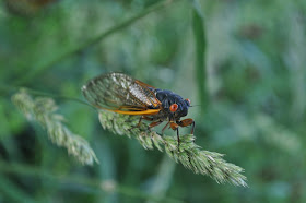
We parked at trailhead on Taylor Road, where the Sweet Clover and Jessup Trail start. Right at the beginning of the trail there was a massive gathering of 17-year cicadas, with thousands of them flying around the grassy meadow area and making a deafening whirring sound. The first mile or so of the hike is along the Sweet Clover Trail going through an empty grassy field, with the grass taller then us in some points. The grassy field is unique with a few random tress, and is unlike any other hiking experience in the area. It is important to check ticks after this hike, as both Shimmy and found ticks on ourselves, very likely from this grassy area.
We took the Sweet Clover Trail across the railroad tracks, to the Otterkill Trail across the brook by the waterfalls (this was a challenge crossing due to the recent heavy rains), and then took the the Dark Hollow Trail up the mountain in its entirety. This is a very serious ascent with a good elevation gain, but unfortunately lacks solid scrambles. When we hit the Jessup Trail we took this south. The Jessup Trail is fascinating with the huge bare puddingstone rocks and the dwarf pines. We took the short spur to the Megaliths, where we took a break for lunch. The megaliths are rock formations of giant boulders that presumably cracked off the host rock sitting atop the mountain. They are rounded from glacial activity and are composed of conglomerate puddingstone.
After the megaliths we returned to the Jessup Trail up the short trek from here to the summit. The summit doesn't really have a view, and there is a remnant of a fire tower with a blaze on the rock stating where the fire tower was. From here we went north on the Jessup Trail along the smooth rocky ridge, until the Sweet Clover Trail. We took the sweet Clover Trail down the mountain, to the Otterkill Trail along the side of the railroad tracks, and the picked up the Jessup Trail again and went back through a different part of the grassy field, and back to the trailhead.
 |
| Map of the Route. West Hudson Highlands Map |
 |
| 17-Year Cicadas on an Oak Tree at the Trailhead |
 |
| Trailhead on Taylor Road |
 |
| Shimmy Walking Through the Grassy Meadow |
 |
| A Great Perspective of the Grassy Meadow |
 |
| Waterfall at the end of the Dark Hollow Brook's Descent Down the Mountain |
 |
| The First View on the Dark Hollow Trail. Looking Northeast. |
 |
| Holes in the Ground Where the17-Year Cicada's Emerged From |
 |
| Excellent View Up On the Dark Hollow Trail. Facing East-Northeast towards the Hudson River and Beacon Mountain |
 |
| At the Same View Looking South |
 |
| Me at the View with the Hudson River in the Distance |
 |
| Typical Scenery of Exposed Puddingstone Rock with Dwarf Pines Along the Ridgeline on the Jessup Trail |
 |
| At the Intersection of the Megaliths Path and the Jessup Trail |
 |
| Me on a Megalith |
 |
| Me on a Megalith |
 |
| Me Looking Toward the Megaliths |
 |
| Shimmy on the Megaliths |
 |
| Megaliths |
 |
| Another View of the Megaliths |
| Panoramic 360 Degree View at the Megaliths |
 |
| Schunnemunk Mountain Summit, with an Elevation Marker |
 |
| View Along the Jessup Trail, Prior to the Sweet Clover Trail |
 |
| Waterfall in the Dark Hollow Brook from the Sweet Clover Trail |
 |
| More Cicadas - near the end of the Hike. There were Thousands of these Everywhere |

No comments:
Post a Comment